40
Hasil
perhitungan untuk
setiap
koordinat
pada
zona
gempa
Indonesia
berupa
percepatan
gempa
maksimum
yang
belum
terkoreksi
oleh
pengaruh
jenis
tanah
setempat.
Untuk
aplikasi dalam desain, diperlukan koreksi berdasarkan pengaruh jenis
tanah setempat dengan menggunakan persamaan :
Dimana :
S
=
Koefisien profil tanah, dapat dilihat pada tabel 2.4.
( 2.28 )
A1
=
Percepatan gempa
maksimum hasil perhitungan pada suatu koordinat dan periode
ulang tertentu, dapat dilihat pada tabel 2.5.
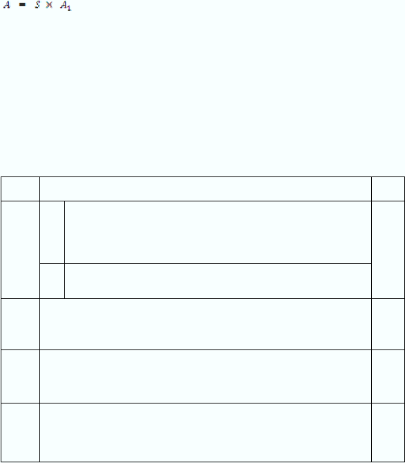
Tabel 2.3. Koefisien profil tanah
Soil
Profile
Description
S
I
1
Rock of any characteristic, eithe shale-like or crystalline nature (such
material may be characterized by a shear wave velocity greater than 760
m/s (2.500 ft/s), or by other appropriate means of classification); or
1,0
2
Stiff soil condition where the soil depth is less than 60 m (200 ft) and the
soil types overlying bedrock
II
Stiff clay or deep cohesionless conditions where the soil depth exceeds 60 m
(200 ft) and the soil types overlying rockare stable deposits of sands, gravels,
or stiff clays.
1,2
III
Soft to medium-stiff clay and sands, characterized by 9 m (30 ft) or more of
soft to medium-stiff clays with or without intervening layers of sand or other
cohesionless soils.
1,5
IV
Soft clays or silts greater than 12 m (40ft) in depth. (such materials may be
characterized by a shear wave velocity less than 150 m/s (500 ft/s) and might
include loose natural deposits or synthetic, non engineered fill.)
2,0
(Lazarte, 2003)